Listing ID #6038208
Company Information
Ask for more detail from the seller
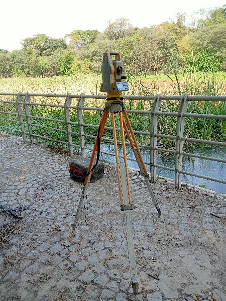
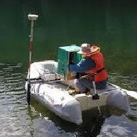
Contact SupplierA water body survey is a comprehensive examination and mapping of features associated with bodies of water, such as lakes, rivers, ponds, reservoirs, and coastal areas. This type of survey is conducted to gather essential information about the physical characteristics, water quality, and surrounding environment of the water body. Water body surveys are crucial for environmental monitoring, ecological assessments, water resource management, and various engineering applications.
Key components and features of a water body survey include:
Bathymetric Mapping: Utilizing sonar technology to measure the depth of the water body, creating bathymetric maps that represent the underwater topography.
Shoreline Mapping: Mapping the perimeter and features of the water body's shoreline, including vegetation, structures, and potential erosion areas.
Water Quality Sampling: Collecting water samples to analyze key parameters such as temperature, pH, dissolved oxygen, nutrients, and pollutants. This information helps assess the health of the water body and its suitability for various uses.
Sediment Analysis: Assessing the composition and characteristics of sediment at the bottom of the water body, providing insights into potential contamination and ecological conditions.
Aquatic Habitat Mapping: Identifying and mapping different aquatic habitats within the water body, including areas important for fish spawning, plant growth, and wildlife habitat.
Hydrographic Surveying: Measuring and mapping water flow, current velocities, and other hydrodynamic characteristics to understand the movement and dynamics of the water body.
Vegetation Surveys: Identifying and mapping aquatic vegetation, such as submerged plants, floating plants, and emergent vegetation, which is crucial for assessing the ecological balance.
Pollution Monitoring: Conducting surveys to identify and monitor sources of pollution, including point sources and non-point sources that may affect the water quality.
Erosion and Sedimentation Studies: Assessing the impact of erosion and sedimentation on the water body, identifying areas prone to erosion and potential sedimentation issues.
Geospatial Data Integration: Integrating survey data with geographic information systems (GIS) to create comprehensive maps and spatial datasets that facilitate analysis and decision-making.
Remote Sensing: Using satellite imagery or aerial surveys to supplement ground-based data collection, providing a broader perspective of the water body and its surroundings.
Water body surveys play a vital role in environmental conservation, water resource planning, and the sustainable management of aquatic ecosystems. The information gathered through these surveys contributes to informed decision-making, helping authorities, researchers, and environmentalists address challenges related to water quality, habitat preservation, and the overall health of water bodies.
Established in the year 2016, we, Lucknow Land Surveyors, are one of the most reputed organizations engaged in proposing reliable and effective Construction and Engineering Survey Services and we also provide service for coordinate verification. We are the registered agent for AAI height clearance. Our offered services are operative and are performed within the stated period with the help of expert & proficient professionals. To keep their reliability and efficiency, we apply the latest methodologies, equipment and higher quality accessories in rendering these services.
We are on the path of constant success and growth under the leadership of our mentor and guide, Mr Umesh Yadav ', our owner who holds huge experience in this field. His outstanding entrepreneurship and guiding skills have helped us in accomplishing our organizational goals.
The services offered by us are
Land Surveying service
Canal surveying service
Topographic Survey Services
Building surveyor survey service
Electric line survey service
Railway track survey service
Soil testing service
And many more in this category
Our strength
With the support of the latest equipment’s and experienced professionals, we bring these services in a prompt, proficient and streamlined manner. Our offered services are under the client’s necessities and international standards of quality:
Why us?
Providing an extensive range of survey services
Excellent team of experts
Equipped with the latest technology
Experienced in many sectors


Connect with us