Products / Services
  • Products / Services
  • Companies
  • Buy Leads
Post Buy Requirement

Levelling Survey

Listing ID #6515888

  • Business Type Service Provider
  • Preferred Buyer Location India only

Precise leveling is a fast, very cost effective and highly accurate method for detecting even the smallest changes in elevation associated with any site activity. Precise leveling techniques have....
View More Details
Send Enquiry

Company Information

  • Member Since 2 Years
  • Nature of Business Service Provider
  • Year of Establishment 2007

Ask for more detail from the seller
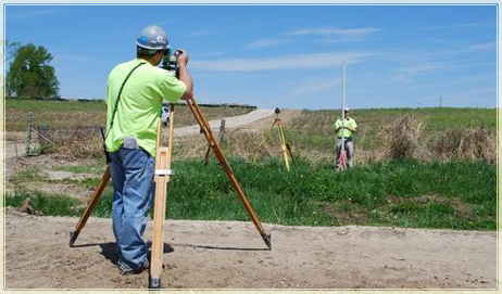
Contact Supplier

Service Details no_img_icon

Precise leveling is a fast, very cost effective and highly accurate method for detecting even the smallest changes in elevation associated with any site activity. Precise leveling techniques have also been used in testing environments, particularly where the effect of stress on a structure needs to be determined. Strategically placed precise level points can correctly and precisely determine the extent of settlement on any structure.

Our company is engaged in offering Levelling Services that are playing a crucial role in rubble removal and land-filling. These services are handled by experienced industry professionals who hold expertise in perfectly understanding and meeting the specific service requirements of our customers. Our services are highly known for cost effectiveness and timely execution.


Company Details close-icon

Geo AdithyA is one of the largest and most experienced full-service geospatial solutions company in cosmopolitan city Chennai, India. We have a long tradition of consistent performance and enduring client relationships built along with quality services.
Geo AdithyA has the experience, technical resources and worldwide capacity to enable excellent performance on any geospatial projects including [ Indoor Service(Digital Photogrammetry, LiDAR, Mobile LiDAR, ORTHO, GIS, CAD, PLS CAD, BIM, Remote Sensing, etc.) Outdoor Services (Total Station/DGPS Survey and UAV(DRONE Survey) etc.) Industries (Forest, oil & Gas, Railway, and Networking)] from multi sensory data fusion for small sites to state-wide mapping programs. Our staffs include surveyors, pilots, engineers, Photogrammetrists, as well as mapping scientists and GIS specialists.
  • Nature of Business Service Provider
  • Number of Employees 50 - 100
  • Year of Establishment 2007
Tell us your Buy Requirement to Get Instant Response
Tell us what you need?

By clicking Get Quotes Now, I accept the T&C and Privacy Policy.

Looking for Levelling Survey?

Quantity
Contact Details
Waiting for permission
To search by voice, go to your browser settings and allow access to microphone

Allow microphone access to search with voice