Listing ID #621371
Company Information
Ask for more detail from the seller
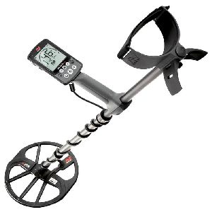
Contact SupplierWe are offering geo examiner gold detector and locator.
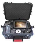
you do not need a laptop to operate the geo examiner. the geo examiner itself is a portable 9" touch screen computer. It has no buttons, switches or adjustments, to operate it simply use the stylus pen or your finger tip on the tft lcd
scan over a tomb. By selecting polygon graphics, targets appear realistic with 3 dimensional contour lines. The examiner images unlike other equipment are not pre-programmed on the software.
underground images in real time:
no time lost to record the area and then send data to a computer to see what you have found. As you walk with the sensors or while you moving the probes - depending the mode you use - the geo examiner shows the underground image immediately. Professional users can also use filters to reveal the images manually adjusting the target strength from the background soil interference.
choose the graphics you want before or while you investigate:
the basic graph - grid blocks are coloured according the data variations, has a target depth calculator and co-ordinate indication, this way you see exactly where the target is and you can pinpoint it again at your next visit.
the high resolution graph - that smoothes out the targets shapes outlining their properties, colourful and detailed.
select the area part you want, or just click on 3d to see the whole 3d view of underground that is automatically rotatable to investigate target shapes from any viewing angle, from 0 to 360 degrees. Numerous features for all graphic types assist to target analysis. A magnetometer survey in 3d. Displays the front side of a bunker and it's entrance as a small red "extension". Depth of the found: 2.5 m. Scattered at the front area are small metal fragments that are easily recognised compared to the solid and vast view of the bunker. The sweep lines co-ordinates are the lines the user walked, while the points are the steps. Total 14 sweep lines with 14 steps on each for this survey.
examiner displays with the graph these co-ordinates to pinpoint the target accurately. The user knows this way which of his steps and sweep lines cover the target. The graph has a 310 degree viewing angle while it can be rotated to a full 0 - 360 degrees view. At left the colour to data scale according to the acquired soil data. Note that there is a great variation between the soil data (blue) and the target (red)
select the best sweep direction:
according to the field layout, the obstacles on your way and your starting position, 8 sweep directions are offered.
choose the suitable direction you want to investigate the field, before starting the survey. Unlike other systems the user is not limited to search only from right to left. Enter to the geo examiner computer how many sweep lines and steps per line you estimate are needed to walk the area.
the geo examiner will then prompt you to step or to turn to the next sweep line with voice commands.
2 data collection modes manual and auto:
for uneven ground when a standard pace cannot maintained, select manual mode, then after every step you make or probes you move (depending the mode used), click on “capture” and see what is found.
on flat ground use auto mode, and input to the computer the time (seconds) needed to make a step, click "start".
the computer will give you voice and visual signals when to step, turn or complete the survey. Your ears prompt you to step, turn or stop and your eyes see the results immediately. If you encounter obstacles on your way like trees or rocks you can pause the data collection, pass the obstacle and start it again
new "replay" function assures that no target is left behind:
a stored image at the geo examiner hard disk can be imported back anytime and be viewed using the "replay" function.
this is not only a "movie" of the original data capture. Use the "replay" and compare investigations from different sweep directions and geo examiner modes on the same site, to validate your target. Often small but valuable targets lying near big ones are masked and are not visible.
the "replay" guarantees that a weak response of either a small or a very deep target will be clearly viewable, then as the "replay" continues and the big target is encountered the small one will fade. It is up to you to investigate again on the suspected target area, leave the big target out of your new survey by selecting another sweep direction and then compare the images.
the geo examiner makes the full target image analysis and target depth calculation immediately on the field. No need to transfer the data file to a laptop to see images in higher resolution you do not pay additional money for extra software just for indicating depth.
specifications
display : 9” led backlight lcd, 1024 x 600 resolution
computer : 1.1ghz processor intell atom
input device : resistive touch panel, finger mouse
operating system : windows 7
working memory : 1gb ddr2
data memory : 60gb hdd
feedback : voice, visual
dimensions & weight : 270mm x 145mm x 20mm 900kg (with battery)
accessories : stylus pen, acdc adapter, power cord, protective bag
safety certification : ce
battery : removable standard battery supports up to 3 hours, option for external battery for up to 15 hours
charging time (battery fully discharged) : ca. 1 hours leather carry bag and neck straps
3 integrated systems
geophysical 4 or 22 probe resistivity measurement. Manual ground cancel control to work at all soil types
gradiometer 80cm. Antenna. Automatic ground cancel
metal detector with discrimination. Manual ground cancel control other optional antenna systems are under development!
frequency range
geophysical: 137hz
gradiometer: +- 50,000 nt
metal detector: 25khz
computer controlled data collection
automatic mode: recording and readings are captured automatically at intervals selectable from 1sec to 100sec
manual mode: manual capture. Real time data graphics for both modes
data points
10.000 scans per survey, ability to store unlimited data files on hard disk
data point density
dependent on step-length, distance between measured profiles and system used: from 5cm to 10m
depth of localization
dependent upon target size and distance between probes
geophysical : 40 m.
gradiometer : 6 m.
metal detector : 2 m.
resolution
10 bit5v
ambient temperature
5 to 55 c
data processing
on site real time 2d and 3d presentations, interpretation, modelling, replay, exporting to bmp, jpg, metafile, png and data file formats, printing
languages
english, greek, turkish, farsi

Connect with us