Listing ID #3364380
Company Information
Ask for more detail from the seller
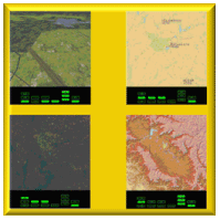
Contact SupplierComAvia's DMG has the ability to display moving maps, overlaid with useful avionics symbols, to the pilot of an aircraft. The DMG greatly enhances the pilot's awareness of his current flight situation and improves his navigational, attack and defense capabilities. It has three main display modes, rendering to the pilot terrain data, aeronautical chart data and satellite data. The first mode of display is fully three dimensional (3D) as seen by a pilot in flight. The other two display modes can be overlaid with avionics symbols such as position of aircraft, its heading, navigational aids VOR and ILS, Ground Proximity Warning (GPW), way points of the flight plan and threats specified by a threat radii. All modes have zoom facility.
Comavia's DMG works with five types of data - Digital terrain data used by the Open Source flight simulator FLIGHTGEAR (FG), aeronautical and civil charts used by the Open Source mapping software ATLAS, satellite imagery in the GeoTiff format (eg. from LANDSAT), Digital Terrain Elevation Data (DTED) from the Shuttle Radar Topography Mission (SRTM) and Compressed Arc Digitized Raster Graphics (CADRG) for aeronautical charts.
Comavia's DMG accepts the aircraft's flight parameters from a network socket, using the UDP protocol or MIL-STD-1553B, at a nominal rate of 50 Hz.
Two additional features that are normally considered part of EGPWS (Enhanced Ground Proximity Warning System) and TAWS (Terrain Avoidance and Warning System) have been integrated with the DMG.


Connect with us