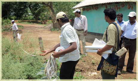
Cadastral Surveys are where property boundaries (for land and strata lots) are defined as an issue of ownership titles. The survey is conducted primarily for the purpose of which is to document the....
Cadastral Surveys are where property boundaries (for land and strata lots) are defined as an issue of ownership titles. The survey is conducted primarily for the purpose of which is to document the perimeters, or any one of them, of a parcel of land by establishing or re-establishing corners, monuments, boundary lines for the purpose of describing the parcel, locating fixed markers on the parcel and dividing the parcel. The Present socio-economic scenario is the focal point of this survey as these help our planner and NGOs in guiding socio-development work.
The Cadastral Survey Services provide a clear picture the effectiveness of our outlays in the sectors. We conduct a detailed analysis as per client's requirement. These analyses are provided in easy to understand format. Data are converted into graph and slides are prepared accordingly.
Company Details
Geo AdithyA is one of the largest and most experienced full-service geospatial solutions company in cosmopolitan city Chennai, India. We have a long tradition of consistent performance and enduring client relationships built along with quality services. Geo AdithyA has the experience, technical resources and worldwide capacity to enable excellent performance on any geospatial projects including [ Indoor Service(Digital Photogrammetry, LiDAR, Mobile LiDAR, ORTHO, GIS, CAD, PLS CAD, BIM, Remote Sensing, etc.) Outdoor Services (Total Station/DGPS Survey and UAV(DRONE Survey) etc.) Industries (Forest, oil & Gas, Railway, and Networking)] from multi sensory data fusion for small sites to state-wide mapping programs. Our staffs include surveyors, pilots, engineers, Photogrammetrists, as well as mapping scientists and GIS specialists.
Nature of Business Service Provider
Number of Employees50 - 100
Year of Establishment2007
Tell us your Buy Requirement to Get Instant Response